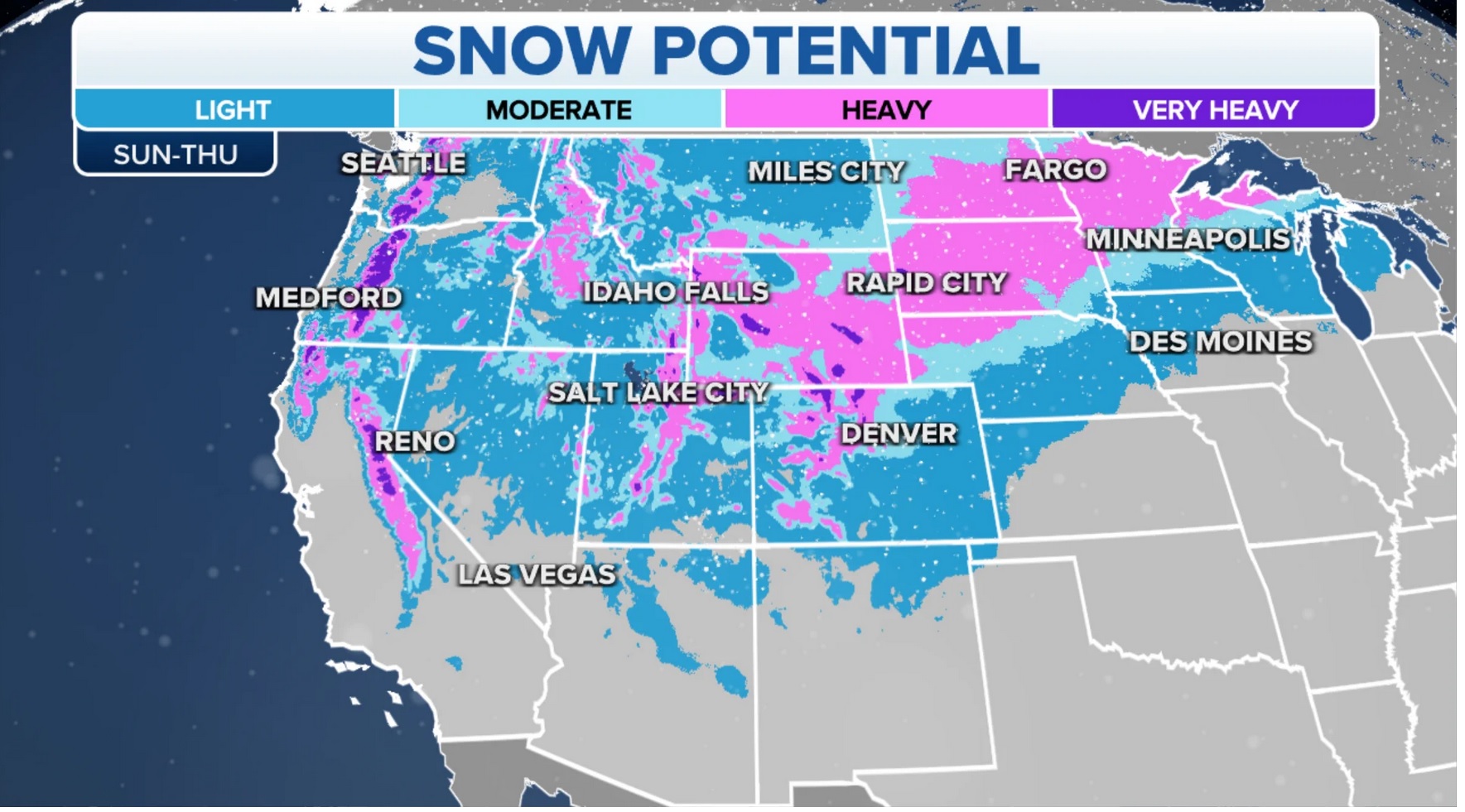
Storm 22 inbound.
Following
a remarkable winter in which back-to-back “atmospheric rivers” pummeled
the West Coast, California’s snowpack levels have climbed to an
all-time high, according to state meteorologists.
The state’s average snow-water equivalent — the amount of water contained in a snowpack — soared to 236 percent of seasonal norms on Thursday, surpassing a 1982-1983 record, the California Department of Water Resources reported.
While
water content in the Northern California snowpack was only 191 percent
of seasonal norms, Central and Southern measurements respectively
reached 234 percent and 297 percent, the agency noted.
This feat was the result of an unusually wet winter, in which 17 atmospheric rivers
barreled into California and 31 total swept across the West Coast at
large, according to the Scripps Institution of Oceanography.
“We have atmospheric rivers to thank for all this recent rain,” the institute, based at University of California San Diego, relayed on Twitter.
Atmospheric
rivers are “long, concentrated regions in the atmosphere that transport
moist air from the tropics to higher latitudes” — producing heavy winds, rainfall and snow, per the National Oceanic and Atmospheric Administration (NOAA).
The
most recent such storm occurred this past week, showering the region
with rain and snow after months of wet weather — and more is on the way
this weekend.
Although this latest deluge was not as dramatic as
previous storms, University of California, Los Angeles climate scientist
Daniel Swain described the event as “remarkable for one thing.”
“It added even more snow water equivalent to
the already record-breaking, essentially 300 percent of average for the
seasonal peaks, southern Sierra snowpack,” Swain said during virtual
“office hours” on Friday.
“This peak keeps getting higher and higher, and I think that it’s probably getting close to the annual maximum,” he continued.
While that peak may be approaching, the storm series has not entirely wrapped up yet.
“There
is one more interesting and very cold system to get through next week,
although it doesn’t look like it’s going to produce very much
precipitation or wind,” Swain said.
The National Weather Service’s Weather Prediction Center forecasted
“heavy mountain snow and lower elevation rain” along the West Coast, from Friday night through Sunday.
This
latest influx, according to the forecast, will likely add “more snow to
the already anomalous snowpack throughout the West.”
Swain
emphasized that this event will probably not yield huge quantities of
snow, but that it will bring “additional snow nonetheless.”
Once
that system departs, however, Swain said that this “might be the
beginning of the end, in terms of California’s very active season this
year.”
“We’ve got about another five or six days of active cold
weather and then things might change pretty dramatically towards warmer
and less active conditions,” he added.
The rain and snow might
soon stop falling, but Swain warned that “all of that water is going to
have to come downhill sooner rather than later.”
He stressed that
during other similarly wet winters, major flooding has impacted
California’s central valleys, which are among the top agricultural
producers nationwide.
Floods already inundating the region could
“affect agriculture for much of the rest of the year” — raising the risk
of plant fungal infections, damage to levees or plant drownings,
according to Swain.